In preparation for attempting a double
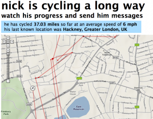
dunwich dynamo (i.e. there and back) I made a web app to track my progress.
I've had it on all week so far tracking my progress to and from work to observer how it works. I've noticed a few things:
- it actually works, yay!
- I appear to be able to cycle straight through buildings
- I can't cycle very fast
- this is a gross self inflicted invasion of privacy
I've been tweaking the app a bit to try and make the total distance and average speed show sensible figures (by not counting periods when I've stopped moving).
One of the main problems though is that google maps and latitude on my blackberry (what I'm using to harvest my location data) only sends out accurate gps information when the application is running in the foreground and visible on the screen. If I put the phone in my bag, after some time it locks itself and pushes google maps to the background. Fortunately latitude will report the accuracy of the reading and I can filter them out. So I just need to find a way to keep it in the foreground at all times (or explore the
yahoo fire eagle based blackberry apps).
It's essentially like
map my tracks but free and just for me (took me a day to make this initial version).
Update: I completed the double dynamo which makes it my longest ever non-stop ride at 250 miles :) the app isn't currently quite working but worked for the duration of the ride - powered by a solar panel on the back of my bike (after the sun came up).

